- 0808.December.Monday
Wetland Bird Survey - Fishlake
Fishlake Main StreetMain Street, Fishlake, DoncasterWhere: Great Ings, Fishlake
Meeting at: On-street parking on Main Street down from the pub/church
What three words: ///heaven.abode.portfolio
Google maps link: click hereWhen: 10am-Midday
What to bring: Walking boots or wellies that you don’t mind getting a bit muddy! It gets very cold on the site so wrap up warm
Bring binoculars if you have them or borrow a pair of ours.
DCRT will bring the clipboards, survey forms and identification sheets.What to expect: Identifying wading and wetland birds can be tricky, so please ask if you are unsure and share your knowledge with others if you know any tips and tricks! These events are great opportunities to practise and learn birding skills, as well as contributing to the BTO’s Core Counts records (read more about core counts here)
Refreshments (hot drinks) provided at the end of the eventJoining us? All are welcome, including beginners.
Sometimes events are cancelled due to flooding on the site or bad weather, please let us know if you plan to attend by emailing [email protected] or texting Sally on 07780333743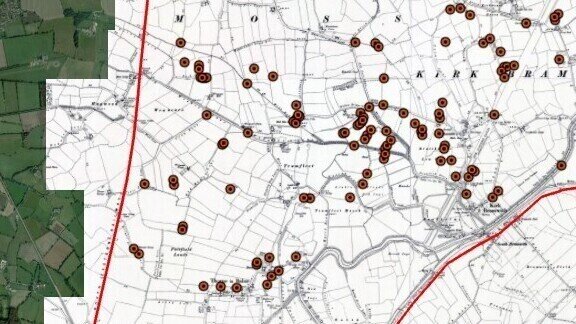
Digital Mapping & Reconstructing Historic Landscapes
DANUM GalleryDanum Gallery, Library and Museum, Waterdale, Doncaster DN1 3BZPlease book your place online https://bookwhen.com/sybrg/e/ev-sbb23-20251208101500
Further details will be sent to those who book a few days beforehand.This introduction to digital mapping is linked to the re-creation of the landscape along the River Don
showing major changes over the last 400yrs. We will show participants how maps can be used to reveal the changes
and build a landscape.The workshop will use commonly available open-source mapping information to peel back the layers
from the modern to the ancient landscape. This will include examples from LiDAR, the historical series
of O/S maps, modern maps and aerial imagery. We will use some case-study examples to illustrate
these. We will also look at using existing and historical features as reference points to help people
understand the changing landscape.There will be opportunities for discussion about the creation of the visualisation as well as the more
formal presentations on using digital mapping.The workshop is part of the Don Catchment Rivers Trust’s All Hands on the Don project made possible
with the National Lottery Heritage Fund.For more information about the project in general, please see the project website page
https://dcrt.org.uk/all-hands-on-the-don/ or contact Rebecca Ford [email protected]
For general enquiries about the workshop, please contact Christine Handley via
Don Catchment Rivers Trust


10/11/2016
